(The following story ran in the Daily Item on Oct. 18, 1998)
I was near the summit of White Cap Mountain when I first saw it.
Mount Katahdin.
Still some 40 miles away, it stood strong and proud, dominant against the central Maine landscape.
I stopped in my tracks. For about two minutes, I just stood there, leaning on my hiking stick, and stared across the miles.
My mind drifted back to Springer Mountain in Georgia, and to the uncertainty I felt as I took my first steps toward Maine. I recalled rainy days in Tennessee and brutal heat in Virginia, water shortages in New Jersey and exhausting climbs in New Hampshire.
I had endured all of this, I knew, to reach a goal. For months, that goal had been abstract. But now, it was right there before me, as real as the cold wind that whipped across my face.
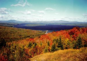
Fall foliage in the “100-Mile Wilderness” of western Maine
The end was literally in sight.
That was fine with me, because the days were getting shorter and colder as I hiked across Maine, and winter in these parts wasn’t far behind.
With the image of Katahdin now firmly etched in my mind, I floated across the remainder of the 100-Mile Wilderness, an expanse of central Maine as gorgeous as it is remote. As I hiked through this wilderness — where there are far more moose than people, far more ponds than roads — I did so with increasing anxiety.
Through the grapevine, I had heard that Katahdin had already been closed to hikers once this fall because of snow, and I knew more snow was a distinct possibility. My worst fear was that, after hiking 2,100 miles from Georgia, I would get snowed out. (Hiking up Katahdin when the mountain is closed can subject you to steep fines. And you don’t even want to think about the cost of needing to be rescued.)
All I need is one day, I kept thinking. Just give me one chance to get up and down that mountain.
On the morning of Friday, Oct. 9, five months and one day after stepping north from Springer Mountain, I reached the base of Katahdin in Baxter State Park. But when I looked at the weather report at the ranger station, my heart just about sank.
Friday: Rain. Saturday: Rain. Sunday: Rain. Monday: Rain likely.
Well, at least it wasn’t snow.
This was the same weather system, it turns out, that caused widespread flooding in southeastern Maine.
My fiancee, Jeanne, had flown to Maine to climb Katahdin with me, and we awoke Saturday morning to temperatures in the 50s and a light mist in the air.
“Not bad,” I thought, “Let’s go for it.”
The hike up Katahdin is one of the toughest on the entire Appalachian Trail. No coasting to the finish here. From the mountain’s base, the trail climbs more than 4,000 feet in just over five miles, topping out at Baxter Peak, the highest point in Maine at 5,267 feet.
Jeanne and I tackled the first mile relatively quickly, but after that, the trail leaves the hemlock and birch forests and climbs steeply up Katahdin’s rocky spine. For three miles we struggled up sharp crags, often scrambling over boulders the size of cars.
Two miles from the summit, we cleared the treeline. On a good day, that would mean spectacular views in all directions. On this day, though, it meant virtually no protection from the elements.
And the weather had turned for the worse. By the time we reached treeline, the rain had picked up and a stiff wind slammed into us from the east. Visibility dropped to about 20 yards, sometimes less.
At one point, Jeanne turned toward me, her voice rising against the wind and quipped, “I hope this isn’t a metaphor for our marriage. I mean, I had hoped for at least patches of sunshine!”
“Well,” I said, “Look at it this way. Whenever we have problems, we can always say, ‘It can’t be as bad as the weather we had on Katahdin!'”
After plodding and sloshing our way uphill for nearly four hours, we reached Thoreau Spring, just a mile south of the summit. Despite the wind and rain, I stopped briefly.
One mile left. Five months and 2,159 miles down, and now just one to go.
At that moment, the magnitude of this hike hit me. Then, more rain hit me, so I started moving again.
Onward we pushed, across an open, rocky plateau on the roof of Katahdin known as the Tableland. Then, through the fog, we saw shapes and heard voices just a few yards ahead of us.
Other hikers. They must be at the summit, I thought. And in a few moments, so were we.
“Katahdin,” the wind-whipped, wooden sign read, “Northern Terminus of the Appalachian Trail.”
I hugged Jeanne and shook hands with several other hikers, some of whom I had met along the way.
Over the last months, I often wondered what I would feel upon reaching Katahdin. Relief? Triumph? Sorrow?
At that moment, I definitely felt triumph, but as soon as I stopped moving, I also felt cold. Sure, it would have been great to linger at the summit and savor the moment, but conditions were miserable. Like so many other times on the trail, Mother Nature called the shots.
The rain and wind continued the next morning, but from the comfort of a bed-and-breakfast in the nearby town of Millinocket, I didn’t care. I looked to the north, toward Katahdin, but the summit was again cloaked in clouds. I would have liked to see it one more time, to bid it farewell.
Katahdin.
The name means “greatest mountain” in the language of the Abenaki tribe that inhabited these woods. It means the same thing, I know realize, in the language of anyone who has thru-hiked the Appalachian Trail.
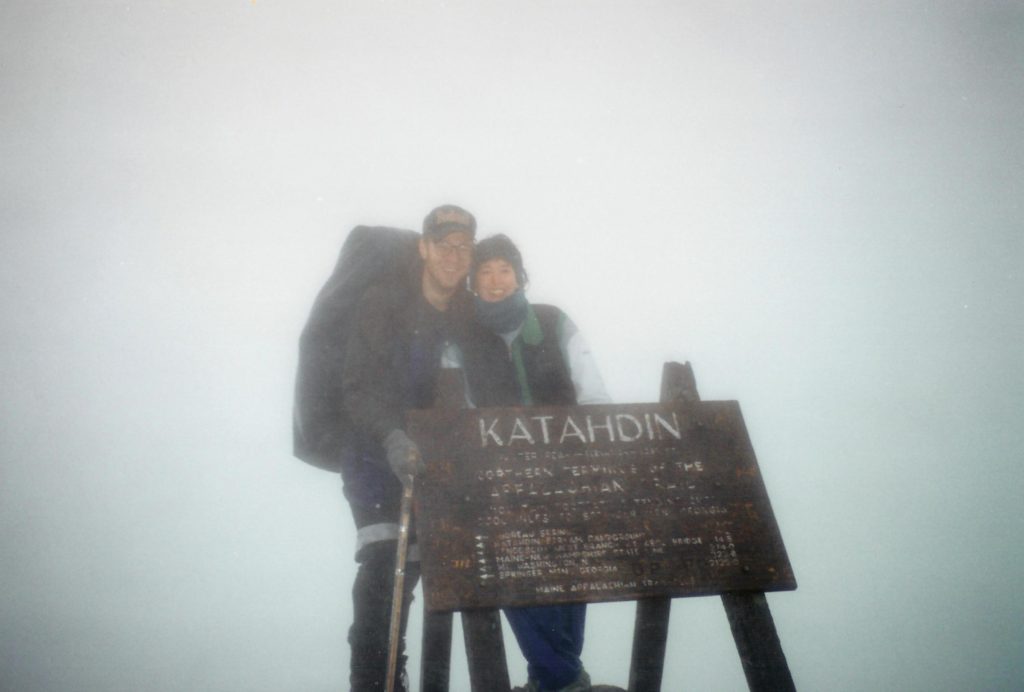
Jeanne and I at the summit after a climb through the wind, rain and fog. I was so happy she was there to summit with me.